A proposal that could've split Port Coquitlam at the polls for the next federal election has been squashed.
On Wednesday (Feb. 8), the Federal Electoral Boundaries Commission for BC submitted its potential constituency realignment to the House of Commons, which is now set for debate and possible objections.
The commission's report will be reviewed by the standing committee on procedure and house affairs between now and May.
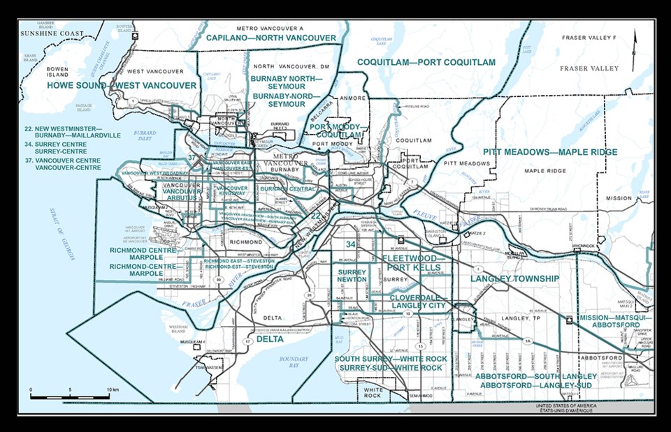
In its previous proposal, the City of Port Coquitlam would have been cut in half with the eastern side joining Maple Ridge and Fort Langley, while the western portion remained in its current riding with Coquitlam.
The original reasoning was to accommodate a growing east Metro Vancouver population.
However, according to the commission's decisions, the reconfiguration was heavily opposed by local residents and politicians.
"This design did not find favour on either side of the Fraser River or Pitt River," the decision report said.
"After re-examining the alternatives, the commission proposes to extensively reconfigure the electoral districts from the Pitt River to Annacis Island and eliminate the proposed crossings of the Fraser River and the Pitt River in this area of the region."
The news has since received relieving responses, including from Coquitlam–Port Coquitlam MP Ron McKinnon and Port Coquitlam Mayor Brad West.
"The Federal Electoral Boundaries Commission for BC has withdrawn their proposal to create a 'Frankenstein' riding that would have joined Port Coquitlam, Maple Ridge and Fort Langley," said McKinnon, who described the possible switch as a political nightmare at a public hearing last September.
"I am very happy to see the commission has listened to the concerns of the Tri-Cities."
A minor adjustment?
If the original proposal had gone through, Port Coquitlam residents living south of Lougheed — including the downtown and the Mary Hill and Citadel Heights neighbourhoods — would've fallen in the Pitt Meadows–Fort Langley electoral district.
Currently, Coquitlam–Port Coquitlam is made up of the following:
- City of Port Coquitlam
- East of Indian Arm and the Indian River
- Pitt Lake Indian Reserve No. 4
- Coquitlam, north of Highway 7A (Barnet and Lougheed)
- Coquitlam Indian Reserve No. 2
For now, though Coquitlam–Port Coquitlam's federal borders will remain as is. But there is one minor realignment the commission has submitted for consideration.
Westwood Plateau residents could be joining Port Moody–Coquitlam as a way to balance the population between the two local ridings, if the realignment proposal is approved.
The BC Electoral Boundaries Commission is also looking to do the same in adding that Coquitlam neighbourhood and renaming the district to Port Moody-Westwood Plateau.
The provincial commission is starting a final round of public consultations before issuing its final report by April 3, 2023.
If ultimately approved, the changes would be made ahead of the 2024 B.C. election.
Changes elsewhere?
The same goes for an area in southwest Coquitlam that may make federal and provincial switches in the next few years.
Maillardville is now being proposed to join its neighbours to the west in New Westminster–Burnaby, according to the Federal Electoral Boundaries Commission for BC's submitted proposal.
The commission believes by adding lands in Coquitlam, as far north and east as Austin Avenue and Schoolhouse Street, this would also help in balancing the population in the region for future polls.
The riding's new name would be New Westminster–Burnaby–Maillardville. The BC Electoral Boundaries Commission is also making the same proposal under its realignment suggestion.
A decision on the proposed federal representation order could be made as early as this fall, which would mark roughly two years before the next federal election tentatively set for 2025.
For more information, you can visit the following websites:


