As the weather warms up, there’s nothing better than to get out on the trails and enjoy the fresh air.
However, it’s still very much winter on the higher slopes, so until the snow melts out later in the summer, it’s best to stick to the lower trails.
The hike described here highlights a local “all season” hiking option.
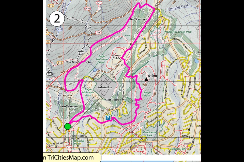
Ridge Park and Eagle Mountain Park
9 km
380 m ascent
This two- to three-hour loop around upper Westwood Plateau takes in several good viewpoints in and around Ridge Park.
Starting from the top of the Coquitlam Crunch, continue northeast on its natural extension, and then follow Salal/Skyridge to the Ridge Park entrance.
At the first T-junction, turn right, following the power lines past a nice viewpoint looking east.
Continuing on, keep to left forking options to a creek crossing with a handrail.
After taking the left fork immediately afterward, the trail switchbacks steeply toward the high point.
There’s considerable trail braiding in this area that can be confusing, but all routes lead to a broad shoulder below the final rise.
From the shoulder, take a steep path that forks right toward the viewpoint at the top, passing over a couple of steep rocky/rooty sections along the way.
From the ridge Park Viewpoint, head north on the main trail and then take the left forking trail just after the highpoint.
As you close in on the golf course, you’ll hit another trail.
Turn right there and then take a left at the trail sign, taking the trail to Parkway Boulevard.
Fifty metres north of where you emerge, take the trail on the opposite side of the road into Eagle Mountain Park.
Once under the power lines, follow them 1 km northwest on the wide track to the intersection with a paved road, admiring fine views of Coquitlam Mountain along the way.
Follow the paved road upward to the end, and then take the trail that follows the gas pipeline cut line.
After about 1 km you’ll come to the gas processing plant.
Go around this on the left side and then follow the paved road down to Eagle Mountain Drive, where you’ll turn right toward your starting point.
Coquitlam SAR Safety Tips: (3 T’s)
TAKE “THE ESSENTIALS” and other necessary equipment:
- flashlight with spare batteries
- extra food and water
- paper map/compass/GPS
- emergency shelter
- signalling devices (whistle, air horn, phone)
- extra clothing (to survive a night out)
- first aid kit
- pocket knife
- fire starter
- bug repellant/sunscreen
TRAIN: Make sure that you and the people you are hiking with (never go alone) are in good enough physical shape to do the hike comfortably and are also mentally prepared. Everyone should have the travel skills needed for the route. You should fully research your route beforehand and check the weather forecast.
TRIP PLAN: Make sure someone will come to look for you if you don’t return, by providing a trip plan to a responsible person who will raise the alert (i.e., call 911). The trip plan can be on old-fashioned paper or in electronic form. To create an online trip plan use the AdventureSmart App or the Overdue App (with maps).
Please consider donating to Coquitlam Search and Rescue in its 50th year. Go to coquitlam-sar.bc.ca to make a contribution.


